I. Goals of the 2018 EPAS Field Season
In our short fifth season of the Erbil Plain Archaeological Survey (EPAS), our goals were:
- Develop a new field survey method based around smartphone (iOS and Android devices) data collection, cloud-based shared spatial databases, and web maps using ArcGIS Online;
- Continue to improve and expand our field protocol for using Unmanned Aerial Vehicles (UAV) or drones to record archaeological sites and features with the addition of a SenseFly eBee Plus fixed-wing high-precision drone;
- Expand the region of intensive investigation to the nahiya (district) of Khabat, where gravel mining of the Upper Zab River and its left-bank terraces threaten ancient sites and landscape features;
- Expand drone coverage to include sites in Shamamok nahiya that were collected in 2012-2013, before our drone program began;
- Train our Kurdish team members in the use of the ArcGIS Explorer and ArcGIS Collector smartphone apps, ArcGIS Online web mapping, and Garmin GLO GPS units so they can use these tools when foreign team members are not present.
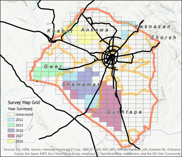
Figure 1. Areas of EPAS Field Survey, 2012-2018. Each grid is 10 km2.
EPAS successfully completed these goals in our 2018 field season, which included 14 field days between 3 and 18 September 2017.
II. Team Members of EPAS 2018
Foreign Project Staff:
- Prof. Jason Ur, Harvard University, USA (Project Director)
- Dr. Rocco Palermo, Groningen University, Netherlands (Postdoctoral Fellow in Classical Archaeology)
- Ms. Petra Creamer, University of Pennsylvania (graduate student in Archaeology)
Kurdistan Region Project Staff:
- Mr. Nader Babakr, Directorate of Antiquities, Erbil (Director of Antiquities and Archaeologist)
- Dr. Narmin Ali, Department of Archaeology, Salahaddin University, Erbil (Archaeologist)
- Mr. Khalil Barzanji, Directorate of Antiquities, Erbil (Archaeologist and drone pilot)
- Mr. Pshtiwan Ahmed, Directorate of Antiquties, Erbil (Archaeologist)
- Mr. Aram Amin, Iraqi Institute for the Conservation of Antiquities and Heritage (IICAH), Erbil (Archaeologist)
- Mr. Mohammed Lashkri, General Directorate of Antiquities, KRG (Archaeologist)
- Mr. Bapir Rashid Bawel (Interpreter, Liason, and Driver)
III. Field Methodology

Figure 2. Field survey using ArcGIS Collector.
Before Fieldwork. EPAS continued to identify sites first using CORONA satellite imagery from 28 February 1967. For the Khabat Region, we also used imagery from the American HEXAGON satellite program (Mission 1202 from 1972) and U2 aerial reconnaissance program (Mission B1554 from 1960). Sites were recognized by their light color against the background of dark wet winter soils. These potential sites were incorporated into a Geographical Information System (GIS) computer database.In 2018, we used shared online maps of the project area using the ArcGIS Online website and the ArcGIS Explorer and Collector mobile apps for iOS and Android (Fig. 2). All project members with a GPS-enabled smartphone and cellular internet access to view an interactive map of all sites, including the 1967 CORONA satellite photography.
In the Field. Field work proceeded in the following manner:
- Geographical information about potential archaeological sites was uploaded onto ArcGIS Online for the area to be surveyed for the day;
- Potential sites were visited by the survey team in vehicles;
- Sites were subdivided into collection areas for complex sites, or collected as a single area for simple small mounds;
- Team members collected diagnostic artifacts (mostly pot sherds with rims, bases, handles, or decoration) from within these collection areas;
- The site’s boundary was mapped via GPS, and elevation points were taken on the highest points of each collection area;
-
For most sites, drone photography was incorporated:
- For most sites, the DJI Phantom 4 drone was flown over the site in parallel transects, to record multiple overlapping photographs. Team member Khalil Barzinji used the DroneDeploy app to plan and fly these fights. The photographs were used in the ArcGIS Drone2Map desktop program to create digital elevation models (DEMs) of resolution around 15 cm, and to make orthophoto mosaics of 4-5 cm resolution;
- For three sites, a new SenseFly eBee Plus drone was used to capture vertical images of the site. We tested this new drone on three of our most important sites: Site 17 Baqrta, Site 27 Surezha, and Site 31 Kurd Qaburstan.
- Work began at 5:00 AM and finished between 11:30 AM and 12:00 PM, depending on the daily weather conditions.
In the Lab. Because our focus was on new methods and staff training, we made only small collections, which will be processed and analyzed in the upcoming 2019 field season.
IV. Results for the 2018 Field Season
In the Khabat region, the 2018 survey investigated:
-
84 potential archaeological sites:
- 36 (43%) proved not to be sites;
- 48 (57%) were confirmed as sites,
- EPAS has a total of 578 sites documented since 2012
-
101 artifact lots, including:
- 99 lots of pottery
- 2 lots of clay figurines
- 46 drone flights over 72 archaeological sites and features, covering 14.5 square kilometers, 16,115 aerial photographs, and over 95 GB of images.
Kabat Nahiya Region
The survey team spent most of its field days in 150 square kilometers northwest of Erbil, in the region between Kawr Gosk, Khabat, and Gazna. We used this region to train ourselves in the use of mobile GIS apps (ArcGIS Explorer and ArcGIS Collector). These apps were tested by the project director Ur in 2017 and now were used by all team members.
EPAS was drawn to this region by the extensive damage to the landscape around Kawr Gosk village. Gravel mining companies have moved from the floodplain to the terraces in search of river gravels for cement manufacture. On the terraces, they have systematically removed the soils from above the ancient gravels, removing archaeological sites entirely in the process. EPAS intended to document these modern processes as well as the ancient sites that they threaten.

Figure 3. Sites in the region east of Khabat.
The survey covered the terraces between Kawr Gosk and the northeastern suburbs of Khabat, and several tributary wadis to the east. The northern wadi flowed past Saidan, Gayinj, and Agholan villages. The northern wadi flowed from Jadida Zab to the area near the Kar oil refinery. Above Jadida Zab, this lower wadi had branches that flowed from Ashokan and Daraban, and from Qalachoghan and Gazna.
The hilly terrain made it difficult to use the 1967 CORONA photographs (Feb 1967). We found that U2 aerial photography (Jan 1960) and KH9 HEXAGON imagery (Feb 1972) was more useful. Nonetheless, our rate of “false positives” (i.e., potential sites that were not actually sites) was much higher than in Gwer or Shamamok nahiyas: 43%, nearly half. Most of these “non-sites” were geological features like gravel hills. The 48 sites documented in this region were mostly small and nearly all very close to these main wadis. Some were long-occupied and very high (i.e., 531 Qalat Girda Shir, 539 Gird Sheikh Musl) but most were low mounds of less than 3 m. Most were around 2-3 hectares, although 545 Qalachoghan may be as large as 53 hectares.

Figure 4. Comparative regional site densities.
The wadis east of Khabat have a lower density of sites than other parts of the Erbil Plain. The survey covered 150 square kilometers (fully or in part) and recovered 48 sites. This site density (0.32 sites/km2) is the lowest yet from any part of the EPAS region. This situation may be explained by the difficulty of using satellite imagery to locate sites, but also by the more marginal soils of the Khabat wadis, compared to the flat alluvial plains of Gwer and Shamamok.
The Kawr Gosk-Khabat region includes the damanged remains of two major ancient canals. The first is a large open canal that originated at Kawr Gosk village, and was visited in 2013 by EPAS. It is wide and meandering. The second canal is narrower and much straighter, and it originates east of Kawr Gosk village. The first canal, which we suspect to be Neo-Assyrian (EPAS Period 11, ca. 900-600 BC), has been mostly removed by the movement of the Upper Zab River, but also by gravel mining in the area south of Kawr Gosk village. The second canal is likely to be Sasanian (EPAS Period 15). It survived well up to the 1960s but is increasingly being removed by heavy machinery. We documented the second canal by drone photogrammetry near Site 518 (Figure 5). The canal is over 60 m wide and up to 6 m deep in this area.

Figure 5. The ancient Sasanian (?) canal near Site 518. Terrain from UAV photogrammetry.
Drone Aerial Photography
EPAS has used UAVs (drones) to document sites since the 2016 season. In 2018, we used three drones in our work:

Figure 6. SenseFly eBee Plus UAV (drone)
- As in 2016-2017, our primary device was a DJI Phantom 4 drone. This drone was used for large systematic coverage of sites for the creation of high-resolution orthophotos (ca. 3-5 cm resolution) and digital surface models (ca. 10-15 cm resolution). Flown areas were planned in ArcGIS and loaded into either the DroneDeploy application or the new DJI Ground Station (GS) Pro application. The pilot of the EPAS Phantom 4 was Khalil Barzinji.
- This season we introduced a new drone, the SenseFly eBee Plus (Figure 6). It is a fixed-wing drone capable of flying large areas at long duration. It also has a high-precision GPS, which results in very accurate DEMs and orthophotos without the need for GPS ground control points. The EPAS eBee Plus was impounded by the Asayish when Ur arrived. After two weeks, we were able to retrieve it from the Asayish, thanks to the efforts of Kak Nader Babakr, but we only had the eBee Plus in the field for three days. It was operated by Jason Ur. The eBee Plus proved to be an excellent tool for archaeological survey and its use will be expanded in 2019.
- Our third device was a DJI Mavic Air drone, operated by Rocco Palermo. This drone was used for rapid documentation of three small archaeological sites on an experimental basis in 2018.

Figure 7. eBee Plus flight over Site 17 Girdi Baqrta in the eMotion 3 software package.

Figure 8. Terrain of Site 27 Surezha, derived from eBee Plus drone photogrammetry.

Figure 9. Three-dimensional visualization of Site 27 Surezha, derived from SenseFly eBee Plus drone photogrammetry.
VI. Summary of Results
In five seasons (2012-2013, 2016-2018), EPAS has recorded 578 sites and investigated 930 square kilometers of the Erbil Plain. The landscape is remarkably dense with archaeological sites and landscape features. This overall site density of 0.62 sites/km2 makes the Erbil Plain one of the densest archaeological landscapes in the Middle East.
Acknowledgements
The EPAS would like to express its gratitude for the help and encouragement of the following institutions and individuals:
Kurdistan Regional Government, Iraq:
- General Directorate of Antiquities, in particular its current director Kak Kaifi Ali and its former director Kak Abubakir Othman Zainaddin (Mala Awat)
- Directorate of Antiquities, Erbil Governorate, its director Kak Nader Babakr, and our representative Kak Khalil Barzinji;
- KRG Representation in Washington DC, including its Representative Ms Bayan Sami Abdul Rahman and the Director of Culture and Community Kak Najat Abdullah.